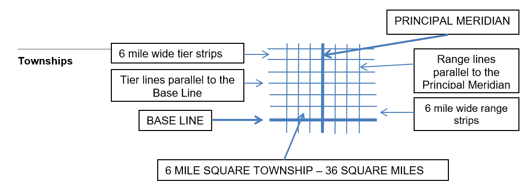
Township Tiers
Lines running east and west, parallel to the base line and six miles apart, are referred to as township lines. They form strips of land called township tiers. These township tiers are designated by consecutive numbers north or south of the base line. For instance, the strip of land between 6 and 12 miles north of a base line is Township 2 North.

Township Ranges
The land on either side of a principal meridian is divided into six mile-wide strips by lines running north and south, parallel to the meridian. These north-south strips of land are called ranges. They are designated by consecutive numbers east or west of the principal meridian. For example, Range 3 East would be a strip of land between 12 and 18 miles east of its principal meridian.
Township Squares
When the horizontal township lines and the vertical range lines intersect, they form squares. The 6 miles square areas are called Townships. These township squares are the basic units of the rectangular survey system.
Townships are six miles square and contain 36 square miles (23,040 acres).
For this discussion, the word township used by itself refers only to the township squares formed by the vertical range lines intersecting the tiers.
Each township is given a legal description. The township’s description includes the following:
Sections
Some features of Townships:
Correction Lines
Range lines are parallel only in theory.
Due to the curvature of the earth, range lines gradually approach each other. If they are extended northward, they eventually meet at the North Pole. The fact that the earth is not flat, combined with the crude instruments used in early days, means that few townships are exactly six-mile squares or contain exactly 36 square miles. The system compensates for this “round earth problem” with correction lines. Every fourth township line,
both north and south of the base line, is designated a correction line. On each correction line, the range lines are measured to the full distance of six miles apart. Guide meridians run north and south at 24-mile intervals from the principal meridian.
Fractional sections and government lots
Undersized or oversized sections are classified as fractional sections. Fractional sections may occur for a number of reasons. In some areas, for instance, the rectangular survey may have been made by separate crews, and gaps less than a section wide remained when the surveys met. Other errors may have resulted from the physical difficulties encountered in the actual survey. For example, part of a section may be submerged in water.
Reading a rectangular survey description
To determine the location and size of a property described in the rectangular (or government) survey style, start at the end and work backward to the beginning. In other words, analyze the legal description right to left. See the Math Section to determine how to calculate property sizes.
In general, if a rectangular survey description does not use the conjunction and or a semicolon (indicating two or more parcels are combined), the longer the description, the smaller the tract of land it describes.
Legal descriptions should always include the name of the county and state in which the land is located because meridians often relate to more than one state and occasionally relate to two base lines.
Metes-and-bounds descriptions within the rectangular survey system
Land in states that use the rectangular survey system also may require a metes-and-bounds description. This usually occurs in one of three situations:
Metes-and-bounds descriptions may be included in the rectangular survey system used in Illinois when describing irregular or small tracts.